
Much of Birmingham’s next big greenway project lives on planning documents. But a few pieces are concrete enough to walk, map and start arguing about.
The Red Rock Trail System’s Action Plan, released in 2023, lays out a 15-year strategy to add 19 miles of new trails and, if fully built, knit them into a 36-mile loop around the greater Birmingham metro area 1. The plan does not just add mileage. It singles out seven priority projects that, when combined with existing Red Rock trails, are intended to link Birmingham with Fairfield, Homewood, Irondale, Midfield and Mountain Brook 1.
That 36-mile figure makes for a tidy headline, but the more interesting story in the evidence is where the loop stops being abstract. Two corridors in particular—one west from downtown, one climbing toward Red Mountain—give a first read on how the trail system might work in practice, long before the full ring exists.
Corridor A: stitching a freeway cut back together
On the west side of downtown, the Action Plan highlights Corridor A, described as running from Smithfield to downtown Birmingham 1. The planning document is explicit about what is being repaired: Smithfield is described as a neighborhood that was historically cut off by Interstate 65 1. The proposed corridor would reconnect it to the city center along an east–west shared-use path.
The same corridor is also routed through the historic Black Merchant District on 4th Avenue 1. That means one continuous path is expected to link three distinct kinds of places: a neighborhood separated by a highway, a civil-rights-era commercial district, and the modern downtown core 1. In city terms, that is less a recreational amenity and more a change in how people can get from one daily destination to another on foot or by bike.
City communication around a related project—the CrossPlex-area Crossroads Trail—confirms how this corridor is being treated. Birmingham describes its east–west shared-use path as the component that the Red Rock Action Plan identifies as Corridor A, and notes that it is one of seven priority projects meant to help create the 36-mile regional loop 2. That language is an announced plan, not a finished connection. But it does indicate that the city is building individual segments that line up with the regional trail map.
The same city document carries a subheading, “4.5-Mile Valley Creek Rail-To-Trail” 2, and notes that this effort has a $4 million U.S. Department of Housing and Urban Development grant attached 2. That grant number is concrete capital tied to a specific piece of the network—even if the evidence here does not spell out every design detail or timeline of that rail-to-trail conversion.
Corridor B: turning 20th Street into a safer climb to Vulcan
On the south side of downtown, a different type of corridor is in view. The plan’s Corridor B follows 20th Street and is described as a link between downtown Birmingham and the Kiwanis Vulcan Trail 1. Where Corridor A is framed around neighborhood reconnection and historic districts 1, Corridor B is explicitly about safety. The planning document says this 20th Street corridor will connect downtown to the Vulcan Trail and “correct vehicular and pedestrian safety issues” along the way 1.
That phrasing is still at the level of a stated intent—no cross-section drawings, no signal timing details are contained in the evidence. But the core idea is clear: the path between downtown and one of Birmingham’s existing ridge-top trails is being treated not just as a scenic route but as a safety project for people on foot and on bikes 1.
In combination, these corridors suggest that the Red Rock loop is being assembled as more than a disconnected string of parks. One runs through a freeway-scarred neighborhood and a historic commercial district 1; another upgrades a major downtown street to fix conflicts between cars and pedestrians 1; a third, the Valley Creek rail-to-trail, is backed by federal HUD dollars 22. Each is different in character, but they share a trait: they connect into existing pieces of the network, not just to themselves.
From regional loop to daily routes
The Action Plan’s headline promise is a future where Birmingham, Fairfield, Homewood, Irondale, Midfield and Mountain Brook are all connected by the same continuous set of Red Rock trails 1. That is an announced geometry, not a present-day reality. The evidence here does not specify which of those intercity links are funded, designed or under construction, aside from the Valley Creek grant figure 2 and the city’s statement that the Crossroads Trail’s shared-use path is aligned with Corridor A 2.
What can be said from the documents is that if the seven priority projects identified in the plan are built as described and tied into the existing trail segments, they are intended to form a 36-mile loop around the metro 11. In that scenario, trails that today feel like standalone assets—like the Kiwanis Vulcan Trail—would become parts of longer routes that span multiple jurisdictions 11.
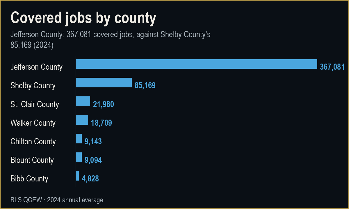
The economic evidence in this packet is high-level rather than corridor-specific. Jefferson County, where Birmingham sits, supports more than 360,000 covered jobs and over 22,000 business establishments as of 2024 33. Surrounding counties such as Shelby, St. Clair, Blount, Bibb, Chilton and Walker each have much smaller employment bases and establishment counts 456789.
Those numbers do not prove that the trail system will change commuting or business patterns. They do, however, frame the starting point: a metro where the core county dominates jobs and firms 33, and several neighboring counties are smaller but growing in establishment counts 456789. If the full Red Rock loop is built and actually used for daily travel, one reasonable inference is that it could make cross-city access within that job base less car-dependent. The evidence here supports that only as a conditional scenario, not as a measured outcome.
How far the evidence actually goes
There are clear limits to what can be said today. The documents establish that:
- The Action Plan exists, was released in 2023 and targets 19 miles of new trails over 15 years to create a 36-mile loop 1.
- Seven priority projects are identified, which together are intended to connect six named cities 1.
- Corridor A is described as reconnecting Smithfield to downtown, passing through the historic Black Merchant District and tying into Legion Field 1.
- Corridor B follows 20th Street, links downtown to the Kiwanis Vulcan Trail and is meant to address vehicular and pedestrian safety problems 1.
- The east–west shared-use path within a city-led project is explicitly identified as Corridor A and as one of the seven priority projects, aimed at helping create the 36-mile loop 2.
- The Valley Creek rail-to-trail segment has a 4.5-mile description heading and a documented $4 million HUD grant 22.
What the evidence does not establish is just as important. It does not list construction start or completion dates for each corridor, apart from the grant award note 2. It does not quantify current trail usage or forecast future ridership. And it does not tie the trail investment directly to real estate prices, business openings or commute-time changes along the corridors.
That means any narrative that presents the Red Rock loop as an already transformative economic engine would outrun the available facts. The verified record supports a more modest claim: specific trail corridors are being planned and, in at least one case, funded as part of a long-term effort to loop the Birmingham metro, with early segments aimed at reconnecting divided neighborhoods, improving pedestrian safety and converting a rail alignment along Valley Creek 1111222. Whether those pieces end up reinforcing one another at the scale of the whole metro is a question that will require future data to answer.
What to watch along the corridor
For now, the most concrete signals to track are on the ground between Smithfield, downtown and Red Mountain. Evidence-backed milestones include:
- Design and construction updates specific to Corridor A’s east–west shared-use path, which the city already identifies as part of a priority project in the Action Plan 21.
- Detailed safety plans and construction activity on 20th Street tied to Corridor B’s goal of correcting vehicular and pedestrian conflicts 1.
- Spending and engineering progress on the 4.5-mile Valley Creek rail-to-trail project backed by the $4 million HUD grant 22.
- Future publications from the Freshwater Land Trust or the City of Birmingham that document which of the seven priority projects have moved from planning to implementation 112.
- Any eventual data releases on trail usage, which would allow the announced goals—reconnection, safety, regional access—to be tested against observed behavior rather than intentions.
Until those arrive, the Red Rock loop is best understood not as a finished ring but as a set of early corridors where Birmingham is beginning to test how a regional trail system might actually function in the city’s day-to-day geography.
Sources
- freshwaterlandtrust.org. Red rock action plan View source
- City of Birmingham. Connecting communities honoring history how crossroads trail joins birminghams growing red rock trail system View source
- U.S. Bureau of Labor Statistics. Quarterly Census of Employment and Wages, annual averages — Jefferson County, Alabama. 2024 View source
- U.S. Bureau of Labor Statistics. Quarterly Census of Employment and Wages, annual averages — Shelby County, Alabama. 2024 View source
- U.S. Bureau of Labor Statistics. Quarterly Census of Employment and Wages, annual averages — St. Clair County, Alabama. 2024 View source
- U.S. Bureau of Labor Statistics. Quarterly Census of Employment and Wages, annual averages — Blount County, Alabama. 2024 View source
- U.S. Bureau of Labor Statistics. Quarterly Census of Employment and Wages, annual averages — Bibb County, Alabama. 2024 View source
- U.S. Bureau of Labor Statistics. Quarterly Census of Employment and Wages, annual averages — Chilton County, Alabama. 2024 View source
- U.S. Bureau of Labor Statistics. Quarterly Census of Employment and Wages, annual averages — Walker County, Alabama. 2024 View source